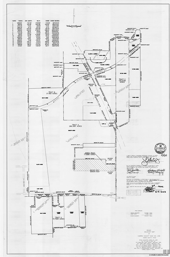
History
Harris County Municipal Utility District No. 230 was created by the Texas Water Commission, now the Texas Commission on Environmental Quality (the “TCEQ”), in 1983, and operates pursuant to Chapters 49 and 54 of the Texas Water Code, as amended. The District contains approximately 519.5 acres of land. The District is located entirely within Harris County, Texas, approximately 20 miles northwest of the central business district of the City of Houston, Texas. The District is located partially within the extraterritorial jurisdiction and partially within the limited purpose jurisdiction of the City of Houston and entirely within the Cypress-Fairbanks Independent School District. State Highway 249 approximately bisects the District from north to south and Cypresswood Drive approximately bisects the District from east to west.
The land located within the District has been developed to date for single-family residential, townhome, multi-family residential and commercial usage. As of April 1, 2018, the District contained a total of 766 single-family homes and townhomes that have been constructed on all of the 766 total lots that have been developed within the District (including 691 completed single-family homes and 75 completed townhomes), all 766 of which homes and townhomes have been sold to home purchasers. Above-ground improvements that have been constructed to date within commercial/multifamily residential reserves that have been developed within the District include a total of approximately 830,997 square feet of completed building area contained in commercial and office/medical buildings and a total of 2,051 completed apartment units. In addition, an approximately 4,000 square foot convenience store and an approximately 40-room motel are currently under construction within the District. The development of approximately 436.8 of the approximately 519.5 acres located within the District is complete. Such acres have been developed into 766 single-family residential lots, including 75 townhome lots (a total of approximately 187.1 acres) in the residential subdivisions known as Mandolin Village, Sections 1 through 4, Gary Simpson Memorial Park, Sections 1 and 2, the Mandolin Village Townhomes, Grants Trace and Fairlane Village; and a total of approximately 249.7 acres of commercial/multi-family residential reserves, including the completion of underground water distribution, wastewater collection and storm sewer facilities and street paving to serve the single-family residential and townhome lots; and trunk underground water distribution, wastewater collection and storm sewer facilities and street paving to the perimeters of the commercial/multifamily reserves.
District Map